A Brief History of the Merrimack River

A lithograph print (1856) of the view from the bridge across Amoskeag Falls by J. B. Batchelder. (1825-1894). This illustration is a romanticized view of what early Manchester may have looked like.
Courtesy of the Manchester Historic Association
The Merrimack River is New Hampshire’s central artery. The meandering 110-mile waterway provided a highway for the dugout canoes of the Native American that first settled the Merrimack Valley and the gundalows of the European settlers that came later. It powered the mills that fueled the Industrial Revolution and allowed riverboats to carry goods from Boston as far inland as Concord.
The river has had its ups and downs. It was pristine in the days of our earliest settlers and so polluted during the Industrial Revolution that it changed colors depending on what materials were being dyed at the textile factories. In recent years it’s been cleaned up substantially.
It’s a flowing record of our state’s history. So why do so few of us barely remember it’s there?
In “A Week on the Concord and Merrimack Rivers,” Henry David Thoreau recalled his 1839 journey up the Merrimack. “The river is by far the most attractive highway, and those boatmen who have spent twenty or twenty-five years on it must have had a much fairer, more wild, and memorable experience than the dusty and jarring one of the teamster who has driven, during the same time, on the roads which run parallel with the stream.”
In the past century railroads and highways have replaced the water as the main route of commerce. The mills have closed, ferries that once provided transport across the river have disappeared. The homes and public buildings that once faced the river now look out on the roads that have superseded the water as the main means of travel. The canals, locks and towpaths that once made river travel possible have been overgrown or disassembled.

Old South Burial Ground is the final resting site of Thomas Lund and many others who were interred here in the 1700s and 1800s.
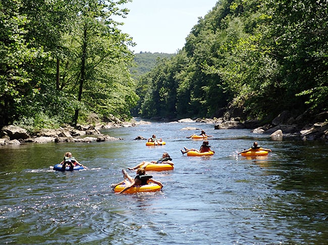
But, if you know where to look, remnants of the river’s glory days may still be found. We set off in search of the source of the Merrimack with an eye to the sites where history and the river intersect and people still come to play. We wanted to discover or rediscover why the Merrimack was, and is, so important to us.
Unlike Thoreau, who chose a dory, we traveled by an ancient Camry and on foot so our discoveries could be accessible to everyone. We took the same northward route chosen by Thoreau. A fondness for going against the current must be a trait we share with the author of “Walden” and “Civil Disobedience.” But we literally started in our own back yard where we’ve watched the Merrimack rise and fall past for nearly three decades on its way through our state to Newburyport, Mass., where it empties into the Atlantic.

The Taylor Falls Bridge connecting Nashua and Hudson was built in 1827 as a toll bridge. The current structure is the fourth at that site.
The Sagamore Bridge crosses the Merrimack River from Hudson to Nashua north of the Massachusetts state line, and connects Route 3A to the Daniel Webster Highway. The bridge has a walkway that offers a panoramic view of the river below, but you seldom see people using it. A steamboat once plied the river from here to Lowell, but that was before the railroad arrived in 1838. It’s worth the trip to cross the river here on foot and look down on the water that seems to change in color from storm-cloud gray to pale blue and sage, depending on the weather and the season. If you’re lucky you’ll see members of the Independence Rowing Club, headquartered in Nashua’s Crown Hill Section, on their narrow sculls, making their way like slender giant water bugs.
Back on the Hudson side of the Sagamore Bridge a Wal-Mart and Sam’s Club crowd the horizon with big-box pyramids. On the Nashua side a line of strip malls and indoor shopping centers stretches to the Massachusetts border.
But look closely: Tucked between the Royal Ridge Center and a Japanese restaurant, barely noticed by drivers rocketing by on the Daniel Webster Highway, is the Old South Burial Ground, the final resting place of some of the area’s earliest
settlers. The site was visited by Thoreau and hasn’t changed since. Festooned with a winged skull is the grave of Thomas Lund and seven others who died in a skirmish with the Indians on 1724. The quaint inscription reads, in part:
This man with seven more that lies in
this grave was Slew All in A day
by the Indiens
A lot to consider as we moved north on the Memorial Bridge on Route 101 from Hudson to Nashua overlooking the mouth of the Nashua River. The Nashua Indians once camped on the site, but that was before the Europeans arrived.
In September 1724 Nathan Cross and Thomas Blanchard were tapping pine trees just north of the Nashua River to make turpentine, when they were kidnapped and taken north by Indians. Ten colonists including Lund set off to rescue them but all but one were killed up river in Thornton’s Ferry. Blanchard and Cross were eventually released by their captors in Canada. Cross’ gun can be seen today at the Nashua Historical Society.
Down the street from the historical society, at Greeley Park, is one of the few public boat ramps that still exist on the southern end of the Merrimack. Farther north, there are more including ramps at Franklin High School, Jamie Welch Park in Boscawen, Penacook Treatment Plant and Sewall’s Falls Dam in Concord.
We pick up the river again on the east side, on the Charles Bancroft Highway from Hudson to Litchfield. It is not nearly as developed as the west, where the train rails were laid but the land is now sprouting condominiums instead of corn.
One of the remaining working farms, Wilson’s, has fields that abut the Nesenkeag Brook Trail, which follows a trout stream a quarter of a mile or so toward the Merrimack. You can hike up to an overlook on the top of the stonework for an old trolley bridge, a reminder of the nearly three decades trolleys made regular daily trips from Nashua to Manchester.
We continue on and once again cross paths with the Thoreau trip in Litchfield village, where a simple white church still stands as it did when Thoreau rowed by. This was the old stomping ground of the Indian sachem Passaconaway, who is said to possess magical powers including making water burn. Passaconaway made his home on an island in the river. A golf course that bears his name is now the only reminder of his presence there.
Shortly after the golf course is the Moore’s Falls Conservation Area. You can take a path down past an abandoned beaver pond to the banks of the Merrimack, where the stonework of the locks that once raised canal boats over the rapids can still be seen during times of low water.
On the opposite side of the river we took the Daniel Webster Highway north from Nashua to Merrimack. On the high ground just north of the Anheuser-Busch Brewery is the former site of the trading post established by John Cromwell about 1665. We passed The Common Man restaurant, formerly the Hannah Jack Tavern, which in the early 1800s was run by Declaration of Independence signer Matthew Thornton.

A major flood in 1936 wiped out several bridges in Manchester.
Just north of Tortilla Flat Restaurant on 3A, we took a right onto Depot Street and entered the site of Reed’s Ferry, which was the main river crossing in the 18th and 19th centuries. Large, sturdy 19th-century houses with barns and mansard roofs are a reminder that the area was once a bustling river port. You can leave your car at a park, walk through a tunnel under the railroad track to the riverside where cut stone walls shade a roadway leading to the water’s edge. Still clearly visible is a succession of steps leading into the river, which once accommodated the arrival of boats at any water level when the river was in its glory days of transportation.
We get back in the car and drive north to Route 293 and gaze down at the river and see on Carthagina Island, nearly a half a mile long, and heavily wooded looking much as it did to Thoreau in 1839.
In Manchester you don’t have to look hard to find evidence of the river’s influence. The battlements of brick mill buildings that stretch for a mile take care of that. It’s here the Industrial Revolution came to New Hampshire. We strongly suggest a visit to the Millyard Museum on Bedford Street for the fascinating details of that part of New Hampshire history.
But the price of progress was pollution. For more than a century, the Merrimack was considered one of the most polluted rivers in the country. After passage of the Clean Water Act in the early 1970s, untreated discharge was no longer allowed into the river and wastewater treatment facilities were built. The river is now relatively pollution free, except in times of flood, when the overflow from treatment plants in Manchester and Nashua fouls the water.
But the waterway has a keen watchdog in the Merrimack River Watershed Council, which considers itself the “The Voice of the River.”

Robie’s Store in Hooksett is a regular campaign stop.
The nonprofit group serves as an advocate for the wise use and environment of the river and the land surrounding it and offers a number of educational programs and paddling tours of the Merrimack.
Just north of the mills is Amoskeag Fishways, owned and operated by PSNH, that still draws power from the mighty Merrimack. The fish ladder there helps salmon make the leap over Amoskeag Dam, where three turbines provide power to the city. The Merrimack is home to 19 resident species, including eight that are attractive to anglers. In fact the New England River Protection and Energy Development Project ranked the Upper Merrimack River highly significant as an inland fishery.
The New Hampshire Fish and Game Department regularly stocks the Sewalls Falls area and tributary streams with brook and rainbow trout.
Still heading north, we followed the river in Hooksett to Robie’s Country Store off Route 3A. It is so old the original building had a dock and received merchandise by river barge until the railroad arrived. Robie’s been almost a required stop for presidential primary candidates, to which the vast collection of political-o-bilia can attest. In spite of the gifts and products that obviously cater to a tourist trade, it’s still a bona fide community meeting spot with a great breakfast. And don’t get us started on the fantastic crêpes.
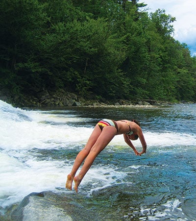
At the town of Pembroke, the Suncook River empties into the river. This was one New Hampshire resident’s playground as a child.

Turn-of-the century ferry crossing the river near Hooksett.
“It was really a Huck Finn kind of thing,” says Michael Plourde, 56, a guidance counselor who grew up in Pembroke and now lives in Nashua. “The river is where we played.”
Although Huck’s Mississippi was a tad cleaner than Plourde’s Merrimack.
“Mainly we’d fish all day, but they were funky fish. We never would have dreamed of eating them. When I was a kid, raw sewage was still being dumped into the river. There was bass, pickerel, horned pout and what we called suckers. They were the ones that hung out at what we called the s–t pipe, where the effluent from Concord came in. I remember we would make spears out of broomsticks and hunting knives and we tried to fish like the Indians. The river was a big part of our town and our life. We would float down on our inner tubes for hours and watch the rich people with their boats.”
Plourde also remembers when hot water was pumped out of the power plant in Bow into the Merrimack. “We would go there in the middle of winter, strip down to our bathing suits and swim. It was like a Jacuzzi.”
And then efforts were made to clean up the river in the 1970s. “In fact our town was one of the first to get involved in the cleanup effort and, even though, it still has problems,” says Plourde. “It’s great to see the river getting better. It gave us so much to do as kids.”
Concord is famously a city with its back to the river. The broad concrete ribbon of I-93 runs between the Merrimack and a charming downtown, but nearby is arguably the state’s best view of the river. Perched on an overlooking bluff in East Concord is the award-winning energy-efficient headquarters and Conservation Center for the Society for the Protection of New Hampshire Forests (www.spnhf.org). The building itself is worthy of a tour, but you can also stroll about 100 acres of Forest Society land dedicated to trails along the river through pine plantations and meadows.
But the river hasn’t just been the setting for recreation. It’s also been the setting for some high drama.
We head to a park and ride on Route 4 in Boscawen to hunt down the Hannah Duston Memorial, a monument installed in the late 19th century on a small island at the confluence of the Contoocook and Merrimack Rivers, where the Colonial mom executed and scalped the Indian captors that abducted her and killed her baby (see sidebar on p. 54). The tall gray statue in such a remote location has endured its own share of abuses over the years. Hannah’s granite nose has been chipped off and repaired, and it’s a rare season that goes by without someone painting the scalps and tomahawk she carries blood red.
The confluence of river and American history doesn’t end there. Archaeological surveys have shown at least four Native American sites on the river, dating from 8,000 to 350 years ago.
And what drew indigenous people to the waterway, drew early settlers and later, during the Gilded Age, American entrepreneurs? What we now know as Concord was first settled by the Pennacook tribe, who strung nets across the rapids to catch the salmon, sturgeon and alewives on their migratory path and planted crops in the fertile flood plain of the river.
Later Europeans came to the prime spot on the Merrimack and by the 19th century a dam was built on Sewalls Falls, which is still thought of as the longest timber crib dam in the world and one of the oldest hydroelectric dams in the country.
On the east side of the river the colonists were engaged in another form of industry. In the town named for the Archbishop of Canterbury was a stockaded trading post, where Captain Jeremiah Clough traded with the Pennacooks in the 18th century. It later became the site of a Shaker village, which may still be visited today.
Not too far north off 3A in Franklin is Daniel Webster’s former farm. The silver-tongued orator used the 141-acre riverside spread as a retreat, model stock farm and meeting place until his death in 1852. Six years ago the farm was sold for development, but it was eventually saved by the Trust for Public Land and other preservation groups. The Franklin Historical Society hopes to open a museum on the site one day.
Two and a half miles north we arrive in the town of Franklin, Webster’s birthplace, and a little farther on, Franklin center. Behind the Franklin High School, off Central Sreet there’s a boat ramp and another public access point on the south end of town off Holy Cross Road. The road gets its name from the Old Sisters of the Holy Cross property on the historic farmland of Daniel Webster. The Fife family still raises hay and feed stock on pastoral lands nearby. Sightings of bald eagles and osprey are not uncommon in downtown Franklin.
We know that the source of the Merrimack is here at the confluence of the Pemigewasset and Winnipesaukee rivers. Thoreau, always looking for the deeper truths, noted that the waters that converge here issued from “the iron region of Franconia … with Squam, and Winnipiseogee (Winnipesaukee), and Newfound and Masssabessic lakes for its millponds.”
Indeed the cradle of the Merrimack and the very source of its might is the wild heart of the state.
Poetic images aside, we found it, truth be told, a little anti-climatic. Franklin calls itself “The Three River City,“ but we didn’t hear any trumpets sounding nor even a sign to indicate the source of the mighty Merrimack that has drawn people to it for thousands of years.
So for final words of reflection, we turn back to Thoreau who referred to the source as “a silver cascade which falls all the way from the White Mountains to the sea …”
That’s more like it.