Perambulating at Muchyedo Banks
Canoeing through history down the Merrimack
We park the truck and begin our journey at a Boscawen boat launch on the west side of the Merrimack River. Our canoe put-in is just north of the point where the Canterbury–Northfield town line intersects with the river on the east side.

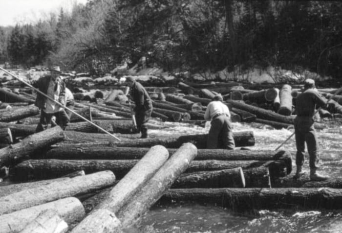
Our merry band explores the island with a remnant bridge pier to search for the town line marker.
This is important because our stated objective for the day is to “perambulate” the Boscawen–Canterbury town boundary. Our secondary goal is to have some fun floating down the river. Representatives from Canterbury and Boscawen join our merry band to satisfy the requirements of the New Hampshire perambulation law, which requires that selectmen of adjoining towns “walk the common boundary lines” and renew the marks and monuments every seven years.
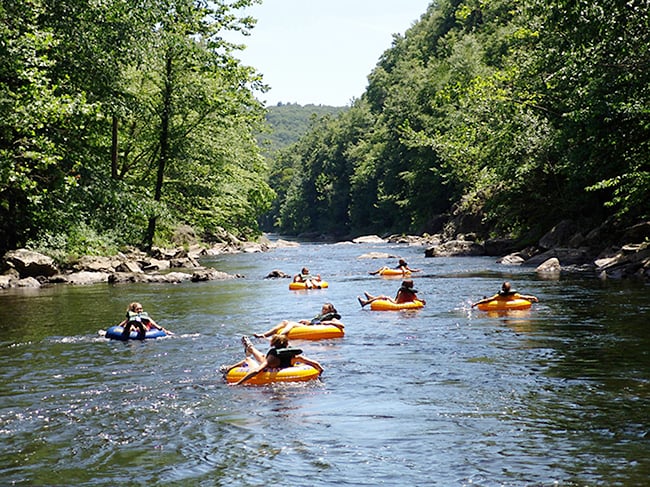
Since we can’t walk on water, we’ve decided floating will have to do. We push off and begin paddling downstream, searching for this unobservable town line.
We float past the county jail where, in the 1950s, prisoners with nothing to do but stare out the window watched a farm on the opposite side of the river. They never saw the farmer working in the fields or his animals grazing in the pastures, but they did observe truck headlights hauling produce all night long.
Prisoners also wondered why the snow regularly melted off the roof of the barn but not the house. When a suspicious sheriff raided the farm, the owner was busted for making illegal moonshine in a hidden room beneath the barn.
The towns of Boscawen and Canterbury are divided by the Merrimack River, so it may not seem necessary to verify the location of this town boundary, but old records indicate a history of contentious lawsuits in the early 1850s disputing the exact location of this town line. Canterbury and Boscawen agreed that the center of the river was the town line, but they disagreed on how the river’s center was determined.
In the lawsuits, one town argued that the center of the river was determined by splitting the difference between the parallel opposing riverbanks. The other town argued that the deepest channel of the water represented the true middle of the river and therefore the town line location.

The Merrimack River zigzags widely in this area, swinging from bank to bank with lots of bank-hugging, elbow turns leaving long, flat, open areas between the high and distant banks. Thus, the difference between the two debated town line locations was significant. Equal access to the water during low water conditions, ownership of the islands, and ownership of sand and gravel mineral rights were in play depending on which way the courts ruled.
After much legal wrangling, to the dismay of abutting landowners who perhaps lost access to the water during droughts, the court ruled that the center of the river and town line were determined by splitting the distance between the banks, regardless of where the water was. The wisdom of the court seemed to be that splitting the banks would result in an equal cost burden for the two towns during construction and maintenance of any bridges spanning the river. The court also ordered that this newly decreed line be marked on the ground with permanent monuments, as the sandy banks continually sloughed away with the eroding river.
Establishing permanent monuments in a flowing and shifting sandy riverbed is easy to order but difficult to accomplish. The only monument ever established for this decreed town line was a mark in the middle of the Canterbury–Boscawen bridge.

The center pier, located on a small island that once held up a bridge (which is now gone).
However, this bridge was later removed, leaving only a center pier rising like a pyramid from a small island in the river. When we reached this island, we stopped for refreshments and searched the pier unsuccessfully for the historic boundary mark. It seems likely it was located on the removed portion of the bridge and is now gone forever.
After paddling the river in a canoe, I find that I disagree with the 1851 court decision. I think the center of any river is better defined by the location of the water, rather than distant eroding sandbanks equitable to bridge builders. Our group of perambulators concludes we are not interested in pursuing an appeal of the court’s ruling, so we shrug our shoulders and continue paddling down the river.
We perambulate past the “Muchyedo Banks,” a pair of 60- to 80-feet-tall sandbanks that rise steeply from the river. These banks derive their unusual name from an incident that took place during the Colonial era. Legend tells that an athletic, young Native American man named Pawgemucket stole the “stylish, ancient, velveteen go-to-meeting britches” from one of the early settlers in Boscawen.
Pursued by an angry mob, Pawgemucket dove into the Merrimack and swam across to the steep banks on the Canterbury side. He then scrambled up the slippery banks “like a squirrel.” At the top of the bank, he waved the britches over his head and taunted his pursuers to come and get them.
Later, Pawgemucket was asked how he managed to climb up the loose sandy slope. His reply, in broken English, was brief and to the point: “Much ye do” to climb those banks. Other variations of the legend suggest he had stolen a sack of potatoes instead of pantaloons and referred to the banks as “Much-I-do” instead of Muchyedo.
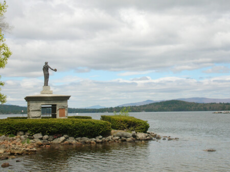
Continuing downriver, we reach Hannah Dustin Island in the mouth of the Contoocook River where it merges with the Merrimack. This island is just south of the point where the Concord town line intersects the Canterbury–Boscawen boundary we’ve been following, and means we’ve completed our goal. We pull our canoes ashore where Hannah Dustin and other captives were brought against their will in 1697, following a raid on their Haverhill, Massachusetts, settlement.

The Hannah Dustin monument looms over an otherwise peaceful island, memorializing when Dustin killed, scalped and escaped captors who brought her there.
A granite statue on the island memorializes Dustin’s story. Hannah Dustin killed and scalped her captors on this island and then escaped downriver in a frenzied canoe ride. That chaotic scene is hard to imagine, as I look around this peaceful spot after my lazy canoe ride to get here.
With the official perambulation now complete, we end our journey and make plans to do it again in seven years, allegedly for the purpose of satisfying the requirements of the law. Perhaps that’s just a convenient excuse to spend a quiet day canoeing down the river and observing some little-known historical legends.
Whichever it is, I now have to figure out how to get back to my truck parked 7 miles upstream.