Into the Great Outdoors: Where To Go Hiking This Winter
These easy-to-moderate hikes will get you outside and enjoying NH’s winter beauty
The mountains transform in winter. Evergreen branches droop under the weight of snow and ice. Tiny tracks of fox and mice decorate the diamond-like surface of freshly fallen snow. And clear, bluebird skies accentuate the white-capped peaks of distant summits, rising up from the dark forests below.
The cold air is revitalizing, and with fewer people out this time of year, the trails are tranquil, offering a chance to pause and reflect on the magical beauty of the season.
But don’t be fooled by the serenity of winter. Clear and calm days are few and far between, and the conditions in higher elevations tend to be drastically different than the weather back home or at the base, even. For those new to winter hiking, consider starting out small with some of these easy- to moderate-rated beginner winter hikes.
Hanson Top Spur Trail
Effingham
Round-trip Distance: 0.80 miles
Estimated Time: 1 hour

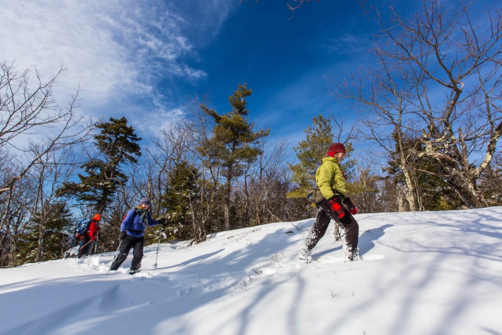
Hikers on the Hanson Trail in Effingham, New Hampshire. Photo by Jerry Monkman/EcoPhotography
The trailhead for Hanson Top (a secondary peak to Green Mountain) leaves from the Libby Road Trail, about 700 feet from the top of Green Mountain. Thus, it can easily be accessed after reaching the summit of Green Mountain from any of the three paths up the mountain. The Hanson Top Spur Trail is a 0.4-mile hike to open ledges at Hanson Top, providing a southern view of the town of Effingham, Province Lake and other distant mountain ranges. This viewpoint is also an ideal setting for a picnic and/or rest.
West Rattlesnake Mountain
East Sandwich
Round-trip Distance: 2 miles
Estimated Time: 1½ hours

Photo by Mary Rogers
The rock outcrop at the 1,293-foot summit of West Rattlesnake Mountain rewards hikers with stunning and close-up views of Squam Lake and the spattering of forested islands below.
With roughly 450 feet of elevation gain, this short hike offers the perfect opportunity for beginners to test winter gear and gain knowledge of the challenging conditions characteristic of this season.
From the parking lot, the mile-long Old Bridle Path features a few short inclines, abbreviated at times where the trail begins to level out and meander around the side of the mountain. Once at the summit, spread a small tarp or rest on a foam sit pad for a picnic lunch.
The trails surrounding West Rattlesnake Mountain are owned by the University of New Hampshire and maintained by the Squam Lakes Conservation Society. Please note that the trails are closed during the mud season, roughly from early April to late May, to minimize impacts on the surrounding ecosystems.
For those feeling confident with the Old Bridle Path trail, the hike can be extended to East Rattlesnake Mountain along the Ridge Trail, nearly doubling the distance of the hike.
Mount Willard
Carroll
Round-trip Distance: 3.2 miles
Estimated Time: 3 hours

Photo by Jill Armstrong
A steady climb up the Mount Willard Trail leads hikers to expansive views of the southern Presidential Mountains, including Mount Washington on a clear day.
After leaving the Crawford Depot and crossing the train tracks, the Mount Willard Trail veers to the left, splitting from the Avalon Trail. About a half mile in, hikers will notice a sign for the Centennial Pool just off the right side of the trail, an ideal spot for a sip of water and an energizing snack. For the final mile or so, the trail continues to steepen gradually.
Near the 2,865-foot summit, hikers emerge from thick trees to rocky ledges to witness the unobscured views of the surrounding peaks and the highway as it cuts through the notch, following the Saco River south. Enjoy a warm cup of tea and note the bold behaviors of gray jays, fluttering in and out of spruce and pine.
A popular hike year-round, this trail will likely be busy. Try setting off right after sunrise to beat the crowds and enjoy the tranquility of the forest after sunrise.
Mount Pierce
Carroll
Round-trip Distance: 6.4 miles
Estimated Time: 5+ hours

Photo by Jerry Monkman/EcoPhotography
For those with previous winter hiking experience, Mount Pierce is a great introduction to tackling some of the 48 New Hampshire 4,000 footers in winter. The summit stands just above 4,300 feet with approximately 2,400 feet of elevation gain.
From the parking lot across the street from the Highland Center, take the Crawford Connector trail for 0.4 miles to reach the historic Crawford Path trail. Take the trail left, following the scenic Gibbs Brook with its series of cascades. At the sign for the Mitzpah Cutoff, stay straight to continue on the Crawford Path trail. While the climb is mostly gradual, there are several moderately steep pitches.
Near the summit, the trail emerges into the alpine zone, where hikers are completely exposed. For this reason, hikers should be prepared with the proper gear and pay close attention to changing weather conditions, knowing when to turn back if necessary.
At this opening, where the Crawford Path meets the Appalachian Trail, enjoy brilliant views of nearby Mount Washington and the other Presidentials before turning right to make the final push to the summit, marked by a towering cairn.
Champney Falls
Albany
Round-trip Distance: 3.1 miles
Estimated Time: 2½ hours

Photo by Erin Paul Donovan
The stunning beauty of winter can truly be felt when viewing Champney Falls frozen over with frosty, blue ice. Grab a pair of snowshoes and head out to this mesmerizing 70-foot-long series of cascades.
Named after pioneer White Mountain artist Benjamin Champney, the Champney Falls Trail begins on the south side of the Kancamagus Highway outside of Conway. The trail up to Champney Falls and accompanying Pitcher Falls ascends at a steady incline, accounting for 700 feet in elevation gain when all is said and done.
After crossing a bridge and walking further into the woods, hikers will spot Champney Brook, which follows alongside the trail for most of the hike. At 1.4 miles, hikers should follow the Champney Falls Loop trail for views of the plunges, cascades and pools.
The Champney Falls Trail continues on to the summit of Mount Chocorua. With its exposed and rocky summit, Chocorua should only be attempted by experienced winter hikers.
Lonesome Lake Hut
Franconia
Round-trip Distance: 3.2 miles
Estimated Time: 3 hours

Photo by Jill Armstrong
After a steep series of switchbacks, the Lonesome Lake Trail opens up to a breathtaking mountain lake nestled between Cannon Mountain and North Kinsman. Although the leg-burning initial push coupled with nearly 1,000 feet of elevation gain can be challenging, the unobstructed view of the snow-covered lake makes the effort worthwhile.
Well-marked by trail signs and yellow blazes, the Lonesome Lake Trail begins from the south end of the Lafayette Campground parking lot in Franconia Notch. After the switchback section, the trail starts to level out, and the forests of maple, beech and birch thin as the lake comes into view.
Follow the trail to the left around the lake to arrive at the Appalachian Mountain Club’s Lonesome Lake Hut, situated at 2,730 feet. The hut is open for self-service in the winter, but feel free to pop inside to warm up and chat with the caretaker on duty.
After lunch, head down to the platform at the edge of the lake for views of Little Haystack, Mount Lincoln and Mount Lafayette across the notch in the Franconia Range. Continue clockwise around the lake to reach the Lonesome Lake Trail back down to the parking lot.
Hiking Tips
No matter the length or challenge of the outing, hikers should always prepare themselves with the proper gear. Year-round, make sure to pack the 10 hiking essentials, which include a map and compass, extra food and water,a headlamp and a first aid kit, among other necessities.
In the winter months, it’s critical to pack proper layers, such as a waterproof outer shell, fleece or synthetic mid-layers and moisture-wicking long underwear, or base layers. Avoid wearing jeans and cotton clothing. Ice traction, such as micro spikes or crampons, are a necessity, but knowing how to use these items is just as important. Snowshoes may be required after recent snowfall to avoid post-holing into deep snow.
For safe recreation in the outdoors, hikers should familiarize themselves with the Hiker Responsibility Code published by the United States Forest Service and New Hampshire Fish and Game. The hikeSafe code champions those who are self-reliant, share their plan and know when to turn back.
Similarly, experienced hikers should know to check weather and trail reports before heading out. It’s smart to cross-check multiple resources for the most accurate information. The Mount Washington Observatory publishes daily reports, including high summit forecasts and other weather conditions. NOAA and Mountain Forecast are two additional weather resources. For detailed hiking conditions and trail reports, check out the New England Trail Conditions and TrailsNH websites.
Finally, if breaking into the winter hiking scene seems daunting, consider hiring a guide. Companies like Northeast Mountaineering and Redline Guiding, both located in the Mount Washington Valley, can provide gear and share their knowledge of the outdoors. And truth be told, there’s nothing better than sharing the idyllic winter views from an open summit with someone else.